East of London riverside hamlets prior to the 19th century

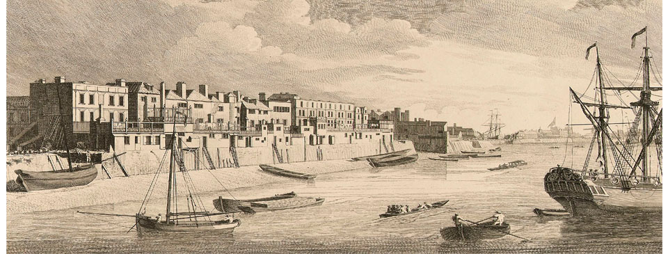
An engraving of Limehouse in 1751 by John Boydell in the early part of his career. He went on to become a successful publisher and Lord Mayor of London in 1790. This view shows 18th century riverside houses and a variety of craft, including a naval cutter heading downstream with passengers, a sea-going ship, sailing barges, and two men manoeuvring a wherry. Several sets of stairs lead down to landing places on the foreshore. In the distance a tall ship is undergoing repairs at Lime Kiln Dock.
Downriver of London the Thameside hamlets on the north bank were quite isolated from the City and surrounding districts until at least the 16th century. They were most easily reached by boat and evolved into communities employed in maritime industries. On the south bank the fishing village of Deptford developed into a major naval shipbuilding centre.
During Roman times there was a settlement in what is now Wapping that included a bathhouse, in existence between the 2nd and 4th centuries. Much of the area was submerged at high tides but a gravel bank that ran parallel with the Thames allowed for a pathway, which in later centuries would become Ratcliff Highway. During the Anglo-Saxon period a church was established dedicated to St. Dunstan at what was then known as Stibenhede. The village of Stepney, as it later became known, gradually grew in all directions around it, including down to the riverside hamlet of Ratcliff where Stepney’s port developed, with cottages inhabited by fisherman and ferrymen. Ratcliff was first mentioned in documents in around 1000 and in the 14th century was referred to as Redclyf. Its gravel shoreline was one of the few suitable landing places below London Bridge.
Other than Ratcliff, the entire riverside area east of the Tower of London, including the Isle of Dogs and Lea Valley, was low-lying and marshy and prone to flooding. It was held by the Bishops of London until the 16th century and in the reign of Edward II their bondmen converted much of Stepney Marsh – the Isle of Dogs – to meadow, with the alluvial deposits making it a rich pastureland. At some point a wall was built to protect low-lying Wapping from the river but the wall was destroyed by flooding between 1560 and 1570. In 1580 much of the marshes came into the ownership of the Crown. Queen Elizabeth had that year issued a proclamation that no new building should be erected within three miles of London. An exception was granted to various people, however, to build along the riverfront at Wapping Marsh to protect the land. Another flood occurred in March 1660. Three days later Samuel Pepys was passing by boat and recorded: “…in our way we saw the great breach which the late high water had made, to the loss of many 1000l [£1000] to the people about Limehouse”. The process of draining the marshes to the west of Ratcliff was undertaken in the early 16th century when Cornelius Vanderdelft, a Dutchman with specialist knowledge in land drainage, was commissioned to oversee the task.
There was a rapid increase in the population to the east of the City in the fifty years between 1580 and 1630, with much of the increase along the riverside. A wall of built-up ground as high as eight or nine feet above the level of the land was created, eventually extending all the way along the shore as far as the River Lea, with drainage ditches dug across the low ground. During the reign of Queen Elizabeth people were encouraged to settle and build houses on or close to the wall so that it would be maintained. Cottages and workshops developed along the water’s edge, creating the hamlet of Wapping-in-the-Wose (‘in the marsh’), with each householder responsible for maintaining the wall. The Elizabethan historian John Stow said that there were no houses there in about 1560 but forty years later Wapping was occupied by “seafaring men and tradesmen dealing in commodities for the supply of shipping and seamen”. The buildings were constructed in precarious and rickety fashion overhanging the wall, interrupted by numerous stairs down to the river. The wall formed the streets of Wapping High Street and Wapping Wall, as well as Foxes Lanes (now Glamis Road), creating a link between London to the west and the hamlets of Shadwell and Ratcliff to the east. Similarly, causeways higher than the surrounding meadows were created with buildings along them. Thus, Wapping evolved as a river-facing community, otherwise isolated by its surrounding marsh.
It was said that a large trade also grew at Wapping in the making and selling of counterfeit goods, outside of the jurisdiction of the City of London authorities. Counterfeit indigo, musk, saffron, cochineal, wax, nutmeg, steel and other commodities were made. Craftsmen of the City petitioned James I. A royal commission was appointed that recommended the authority of London livery companies be extended to a radius of five or six miles beyond the City but nothing came of it.
During the Middle Ages Deptford Strand, opposite the Isle of Dogs on the south bank of the Thames, developed as a fishing village. It was very close to the royal palace of Greenwich and therefore not surprising that Henry VIII chose to develop a naval dockyard there. The village thus became a centre of shipbuilding and repairing and home to marine craftsmen and mariners. A group of master-mariners were concerned with safety on the river and its estuary and in 1513 petitioned the king to form a standard of pilotage. Thus, the organisation that became known as Trinity House was founded, which is still deeply involved in maritime safety around Britain.Sir Thomas Spert, the original Master of Trinity House, was buried in St. Dunstan’s church.


