The re-establishment of London by Alfred the Great

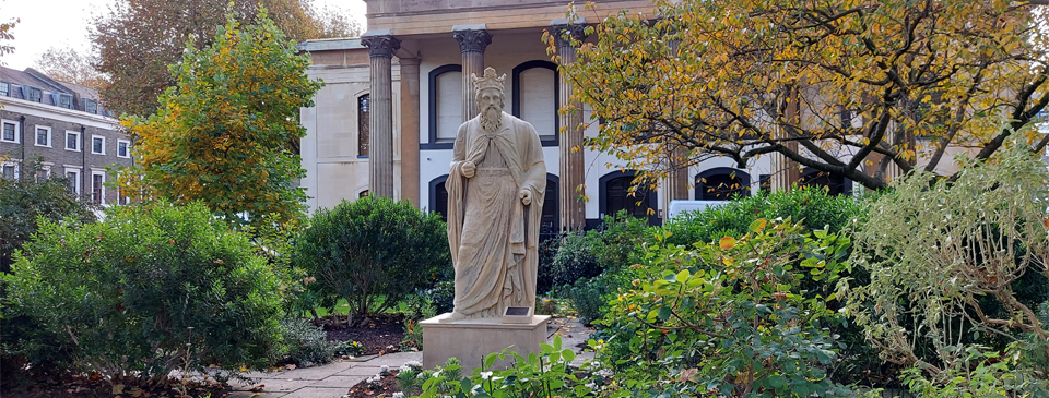
This statue of Alfred the Great stands in the central garden of Trinity Square at Southwark and created in the 19th century. The top half is made of Coade Stone, an artificial material. It was moulded onto the lower part, which is part of a much more ancient statue carved from Bath Stone and believed to be the Roman god Minerva, possibly dating from the 2nd century. The statue may have previously stood in Westminster Hall and removed from there in 1825.
In about 898, 20 years after taking control of London, Alfred met at Chelsea with three of his closest advisors – his son-in-law Aethelred, the Archbishop of Canterbury, and the Bishop of Worcester – to discuss restoration work in London and the laying out of streets. Grants of land were given to each of the clergymen in the area of Aethelred-hithe around the modern-day Cannon Street. A road ran northwards from the river landing-place at Aethelred-hithe (which would be renamed Queenhithe from the Middle Ages). The land to the west of the road was granted to the Archbishop and that to the east to the Bishop. Each of the recipients of these grants was given the right to land boats along their respective sections of riverbank.
It seems that a number of streets in the area of the City leading up from the Thames, some of which still exist today, were laid out during the late 9th century. In some cases they were probably on the same lines as – or re-aligned from – earlier Roman thoroughfares. About ten streets ran down to the river, thus dividing the town into easily definable communities. Each street probably terminated with its southern end at a gate in the riverside wall, originally erected during the Roman period. The main east-west street running through the centre of the populated area ran along the line of Eastcheap, St. Paul’s and Ludgate Hill and then on to Thorn Ea Island (Westminster).
Boats were initially berthed on the muddy beach along the riverside wall, probably because the old Roman quays had collapsed. New embankments were constructed along the river to the west of the Walbrook, partly to protect the wall from the Thames. These embankments were not continuous but acted as platforms that provided dry spaces outside of the riverside wall, which were no doubt used as markets or for docking boats. The slopes or beaches between the platforms continued to give access to the river at low tide, for example allowing animals to drink, and to be able to beach boats.
A new road was laid out through the city between Aldgate and Ludgate with connecting streets to the wharves. A royal palace was built on what is now Wood Street and Aldermanbury and records show that this was used for at least the next 200 years. Houses and workshops were built, with a series of small streets and alleys to connect them. The town gradually expanded northwards, away from the river within the walls, with additional sokes created.
The area occupied by buildings was only around a quarter of the total within the walls. The space along the river from Billingsgate in the west to St. Paul’s in the east and back to Cheapside was fully utilised. The remaining areas were probably used for grazing of animals and market gardening.
The Saxons lacked the technology and architectural skills of the Romans and most of the buildings in London at that time were simple wooden constructions, with stone being reserved mainly for churches. A number of churches within the City of London such as All Hallows and St. Bride’s still contain fragments of Saxon stonework. It is possible that ‘folkmoots’ at which the town’s business was discussed by its leaders and citizens were held in the old Roman amphitheatre, which would account for its continued use as the location of the Guildhall during medieval times.
London had become a strategically important fortress town. The city was well defended, with the former Roman walls repaired on both the land and river sides. To the west the River Fleet acted as a natural moat and there were marshes to the north and east. Yet London was not yet in a position to truly flourish. Alfred’s ceremonial centre was Winchester, and overseas trade appears to have declined in the late 9th and early 10th centuries, as did the minting of coins in London.
It would have been for good reason that London and Southwark were maintained as burhs, or garrisoned towns. Despite the treaty between Alfred and Guthrum, Vikings continued to be a threat throughout the 880s and 890s. Battles took place in Surrey and possibly the Thames Estuary in 882 and at Rochester in 885. In 894 word reached Alfred that the Danes had assembled an army at Benfleet in their territory of Essex so he arrived at London and led its men to meet them. Victorious in the ensuing battle, the Londoners seized or destroyed the Viking ships and earthworks, killed those men who did not flee, and brought their ships, wives and children back to London, presumably as slaves.
Various sources including: Gustav Milne ‘The Port of Medieval London’; Christopher Brooke ‘London 800-1216’; Jeremy Haslam ‘King Alfred, Mercia and London, 874-886: a reassessment’, Anglo-Saxon Studies in Archaeology and History; Jeremy Haslam ‘King Alfred and the Development of London’, London Archaeologist journal, 2010; Tony Dyson ‘Two Saxon land grants for Queenhithe’, London and Middlesex Archaeology Society; John Clark, ‘King Alfred’s London and London’s King Alfred’, London Archaeologist journal, 1999
< Back to Saxons, Vikings and Normans


